14 Facts About Merida Mexico That Will Surprise You
In short
The short version. Mérida is a Maya capital with a Roman name, a cathedral built out of the temple it replaced, a boulevard paid for by rope, Dutch cheese in its national dish, and a landscape with no rivers on it. Fourteen facts, all of them checkable.
The city itself
1. It is named after a Roman town in Spain
The Spanish called it Mérida because the Maya buildings they found reminded them of the Roman ruins at Mérida in Extremadura — a town Augustus built for retired legionaries. One imperial ruin reminded a second empire of a third.
2. There was a city here already, and its name meant "five hills"
T'hó, also recorded as Ichcaanzihó, stood on this ground when the Spanish arrived in the 1540s. The name is read as "five hills", a reference to the pyramids that were still standing.
3. The cathedral is built out of those pyramids
San Ildefonso went up between 1561 and 1598 using stone taken from the Maya temples of T'hó. Look at the walls: the blocks do not match, because they were not cut for this building.
4. It is the oldest cathedral on the American mainland
Not the oldest in the Americas — the Caribbean has older — but the first raised on the continental mainland, and the oldest in Mexico.
5. The city was founded on 6 January 1542
By Francisco de Montejo the younger, known as el Mozo to distinguish him from his father of the same name, who had spent years failing to do it.
Money, rope and a boulevard
6. Paseo de Montejo was paid for with agave fibre
Henequen is an agave grown on the flat limestone north of the city, and its fibre made the binder twine and ship's rope the industrialising world ran on. Between about 1880 and the First World War it made a great deal of money, and the money went into one street.
7. The boulevard was laid out from 1888 on a European model
Deliberately — wide, straight, tree-lined and nothing like the colonial grid it runs out of. The highlights page has the mansions on it.
8. Nylon ended it almost overnight
Synthetic fibre arrived and the market went. What is left is the architecture on Paseo de Montejo and a lot of abandoned haciendas in the countryside between here and Uxmal.
The land underneath
9. The Yucatán has almost no rivers
The limestone is porous, so rain goes straight through it. There is no surface drainage to speak of on the whole northern peninsula.
10. That is why cenotes exist
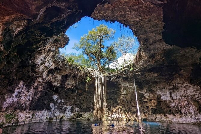
The water runs underground in flooded caves. Where a cave roof collapses you get a cenote, and they were the peninsula's only water supply, which is why the Maya treated them as sacred. The cenote tours page explains the three kinds.
11. There are around thirty of them in one municipality
Homún, an hour south-east of the city, has enough cenotes that a day there means three different ones rather than a queue at a famous one.
12. The peninsula is the rim of an asteroid crater
The Chicxulub impact structure sits under the north-west coast, and the ring of cenotes across this part of the Yucatán traces its outer edge. The city is inside it.
On the plate
13. There is Dutch cheese in the local cooking
Edam arrived through the sea trade with Europe and stayed. It turns up hollowed out and stuffed with spiced pork in queso relleno, and grated into a dessert wafer in a marquesita. The food page has both.
14. Yucatecan food is not a version of Mexican food
The peninsula was cut off from central Mexico by geography and traded by sea instead, with Cuba, New Orleans and Europe. The result is its own cuisine: achiote, sour orange, pumpkin seed, pit-roasting, and habanero used for aroma rather than heat.
The fourteen, in one place
| Fact | The short version |
|---|---|
| The name | Roman, via Extremadura |
| What was here | T'hó, a Maya city |
| The cathedral | 1561–1598, built from T'hó's stone |
| Its rank | Oldest on the American mainland |
| Founded | 6 January 1542 |
| The boom | Henequen, roughly 1880–1915 |
| The boulevard | Paseo de Montejo, from 1888 |
| The bust | Synthetic fibre |
| The hydrology | Almost no surface rivers |
| The cenotes | Collapsed cave roofs over the water table |
| Homún | Around thirty cenotes in one municipality |
| The crater | Chicxulub, and the ring of cenotes on its rim |
| The cheese | Dutch Edam, by sea |
| The cuisine | Its own, not a regional Mexican variant |
How to see each of them for yourself
None of this is behind glass. If you want to check the list yourself, here is where each group of facts is standing:
- The name, the founding and the stone (facts 1–5). Walk the Plaza Grande. You can see the mismatched blocks in the cathedral wall from the pavement, and the Casa de Montejo doorway is thirty metres away across the square.
- The rope money (facts 6–8). Take a car up Paseo de Montejo in the late afternoon and walk back down. You will pass the mansions in about forty minutes.
- The water and the crater (facts 9–12). You have to get in one. Homún is an hour south-east and the cenotes there are open, half open and fully enclosed, which is the whole argument in one day out.
- The cheese and the kitchen (facts 13–14). Mercado Lucas de Gálvez, before eleven, or a food walk if you would rather somebody ordered for you.
If you only have time for one of the four, make it the cenotes. You can read about a collapsed cave roof over a flooded cave system, but you do not understand what the Yucatán actually is until you have swum in one and looked up at the hole in the ceiling.
What we left off the list
Three things you will read elsewhere are not above, and it is worth saying why. The claim that Mérida had more millionaires per head than anywhere on earth during the henequen boom is a period newspaper line rather than a measurement, so we have not printed it as a fact. The population figure moves and the sources disagree. And the "safest city in Mexico" ranking depends entirely on which index you pick.
What is on the list instead is checkable: INAH publishes the cathedral dates, the state government publishes the founding, and you can see the rest from the street. The history page takes the first eight in sequence rather than as a list, and the map and distances page shows how far you have to go for the others.
Frequently asked questions
Are the flamingos at Celestún there all year?
Is Merida Mexico a good base for the Yucatán?
What is the difference between Maya and Mayan?
Tours that show you these
Walking Tour Across the Historic Center in Merida
Two hours, a certified local guide, and under twenty dollars a head.
From $18 per person
Check Availability4 Cenotes Tour in Homún all inclusive from Merida
Three Homún cenotes with every entrance fee and lunch already paid.
From $87 per person
Check AvailabilityTaste of the Yucatan: Merida Cooking Class and Market Visit
Shop the Lucas de Gálvez market, then cook it in a family kitchen.
From $95 per person
Check AvailabilityFourteen facts are a start. A guide standing in front of the thing is better, and the walks and cenote days that cover them are listed with their prices on Merida Mexico Tours.